
Project
Teaching Silk Road History with Google Earth: Spatial and Digital Humanities Pedagogy at University of California, Merced,
- Supported by the Center for Research on Teaching Excellence (CRTE)
- Professor Ruth Mostern (rmostern@ucmerced.edu)
- Introduction
- Grading Digital Maps
- The Google Earth Projects
- Student Learning
- About the Participants
- Rights and Reuse
- The course syllabus includes course objectives, readings, and assignments; and it shows how I integrated hands-on instruction in digital tools into a history class.
- My lab slides illustrated with Silk Road examples, focus on specific Google Earth functions that students needed for their assignments.
Grading Digital Maps
My biggest concern was about grading students on the basis of work submitted in a medium that they had never used before. Indeed, most of them had never been graded on any history assignment other than papers and exams. I wanted to communicate clear standards and expectations.
- I created short assignments, due throughout the semester, that led up to the final digital map submission. The project constituted 65% of the semester’s grade, but no single assignment was worth more than 30%.
- I held extended office hours, particularly before the final due date.
- I developed a detailed rubric that listed the components of a digital map project, explained my expectations about each component, and provided advice.
The Google Earth Projects
All of the students selected a Silk Road travel narrative to study during the semester. They wrote a ten page research paper about it, and in addition, they mined it for spatial information. They created gazetteers of the places the traveler visited, determined the traveler’s route from place to place, and wrote short descriptions of the traveler’s experiences at particularly significant places. They each created interactive maps that integrated all of this material, including even their papers, which focused on the geographic aspects of their travelers’ narratives. This video showcases their accomplishments.
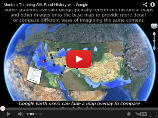
Google Earth was an excellent platform for this project. However, it was not designed for classroom use or for historical content, and it is less than ideal in certain respects.
- It lacks a time-stamping interface, so students needed to write a few lines of KML code in order to time-enable their data. They also had to use HTML to create appealing placemark pop-ups that included images and formatted text. They had to create legends outside of Google Earth and import them as overlays. While these procedures were not difficult, some students found them intimidating or confusing.
- Because Google Earth Community, Google Earth’s public data repository, does not have a provision for creating closed groups, there was no way for the students to share content with one another short of making it public to the world. Since I did not want to require that, I asked students to submit their digital map files to me using UC Merced’s course management system.
Student Learning
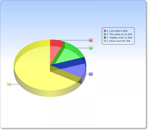
- Almost 80% of the students felt that they learned more about history in this course than in a standard history course, in spite of the fact that half of their class time was occupied by computer labs.
- 75% of the students found Google Earth a useful tool for learning about history, 75% of them “loved” using it, and a majority of them rated the workload for the class as below average in spite of the fact that I demanded more of them than I do in my other classes.
- Their feedback included comments like “It allows us to view different regions and see how cultures spread out through history,” “It’s more interactive and forces the student to be more engaged in his/her work,” “The spatial approach helps put history into perspective,” “When I become a teacher, I will definitely use tools like the ones we have learned this semester in my own classes-they help put a physical location with historical texts,” “It is sooooo nice to use Google Earth in learning about history and to see locations visually. It helps to make the ideas easier to grasp,” and “It was one of my favorite courses to date. I have shown my finished project off to many friends and family and when I teach in the future I want to do something similar.”
About the Participants
Ruth Mostern is Associate Professor and Founding Faculty in the School of Social Sciences, Humanities and Arts at the University of California, Merced. A historian of imperial China with a specialty in geography, her book Dividing the Realm in Order to Govern: The Spatial Organization of the Song State (960-1276 CE) was published by Harvard University Press in 2011. She is currently working on a digital spatial history of the Yellow River and an edited collection of articles about historical gazetteers.
Rights and Reuse
Feel free to use or adapt any of these materials in accordance with Creative Commons license terms. Please contact me at rmostern@ucmerced.edu with information about your own Google Earth course!

This work is licensed under a Creative Commons Attribution-NonCommercial-ShareAlike 3.0 Unported License.


